Explore Toronto's past through maps...

Featuring simple and free access to a broad selection of notable historical maps of Toronto, this site aims to generate curiosity, and to serve as an easy entry point for discovery and further investigation.

1818 Lieut. G. Phillpotts: Plan of York
How did ‘Muddy York’ develop into the modern metropolis we live in?

These important maps from our past reveal the essential tension of this city — between the quest for growth, and the heavy influence of what came before. They reflect a municipality in constant flux, and give insight into our contemporary urban identity.

And besides, who doesn’t love poring over old maps of Toronto?

- Nathan Ng

Start your exploration—complete list of maps
More about this project: background & context
List of most recent updates and additions

Contemporary Maps with Historical Information

The following maps have been selected for the historical information they convey. Although they are contemporary in terms of creation, they may nevertheless be of interest (and hopefully utility) to researchers and students.


This 1967 map displays the annexation date of various city of Toronto neighbourhoods and geographic areas.

Click the image to view a full-size version. [image presented via CTA online website. Unfortunately it’s not downloadable, a restrictive practice I find obnoxious. Nevertheless it’s viewable at an excellent resolution.]


City of Toronto. [Annexation Map] A. Douglas Ford, City Surveyor, City Surveyors Department, January 1, 1967 

Compare to this 1915 version prepared by the Civic Transportation Committee:


Annexation Map, 1915. From Report to the Civic Transportation Committee on Radial Railway Entrances and Rapid Transit for the City of Toronto Volume II

Image courtesy University of Toronto Map and Data Library: Link


This next map can be imagined as a 'Domesday' map; it shows an aggregated view of the landowner names for the initial grants of Crown Lands, within the Township of York (independent of grant date).

Click the image to view a full-size version. [Note: TIF file; you may need to download the image and view it with an image program]


Disposition of Crown Lands. Township of York in the Municipality of Metropolitan Toronto (Formerly in the County of York)

Image from Ontario Ministry of Natural Resources, Plan no. T-2539
via University of Toronto Map and Data Library: G3524 .T6 G463 31 1793- 1976


This colourful map visually displays approximate building construction dates within the City of Toronto, and won a 2005 award for Excellence in Cartography. Dates were “derived from the Toronto Assessment Database and were assigned onto the parcel fabric through the assessment roll number.”

Click the image to view a full-size version. 


City of Toronto Building Construction Dates
City of Toronto Works and Emergency Services, Technical Services, Survey and Mapping Services, Mapping Services.
Produced by Patricia Morphet, September 2003

Image courtesy of City of Toronto: M-20. Used to be available from the city’s Map Product Catalogue.

See also:


Finally check out the following excellent interactive map presented by the City of Toronto. It allows you to display a wide range of different aspects of the city, including aerial photography for various years, the Goad's Atlas maps, and many elements such as boundaries, parks, public art, etc.

City of Toronto: Toronto Maps


Please ‘Like’ and Share these maps with other Toronto history enthusiasts! (+1s are also welcome!)

1836 Lynn: Plan of Building Lots in the City of Toronto the Property of the Hon. Peter McGill

“This plan shows one of the earliest subdivisions north of Lot (Queen) Street. The land was subdivided by the nephew of John McGill, the original owner who built the cottage pictured here. This plan is one of the first to include lanes—an indication that row housing, which requires access at the rear. was anticipated.

Building in this area was slow; an addition to the map shows that an entire block was purchased in 1850 for the site of the Normal School. It is now the site of Ryerson Polytechnical Institute. [now Ryerson University -N.]”

- Isobel Ganton & Joan Winearls, MAPPING TORONTO'S FIRST CENTURY 1787-1884

Click the image to view a full-size version. 

Map: an 1836 subdivision plan by Robert Lynn of lands held in Toronto by Peter McGill, including where Ryerson sits today

Plan of Building Lots in the City of Toronto the Property of the Hon. Peter McGill. Surveyed September 1836 by Robert Lynn D.P. Surr [Sgd] Robert Lynn P.L.S.
Coloured manuscript; 1 inch to 100 feet

Image via Toronto Public Library: Howard Papers 917 [as this item is held by Special Collections, there’s no catalogue citation]

Sorry for the image quality. This item has not been scanned yet by the TPL, so I resorted to some on-site photography, to serve until that day it arrives at the front of the digitization queue and I can make a substitution. Better than nothing I hope!

Herewith some close-ups for inspection (click to expand):


Please ‘Like’ and Share these maps with other Toronto history enthusiasts! (+1s are also welcome!)

1833 Castle: “... merely a Proposed Sketch of an intended addition to the Town of York”

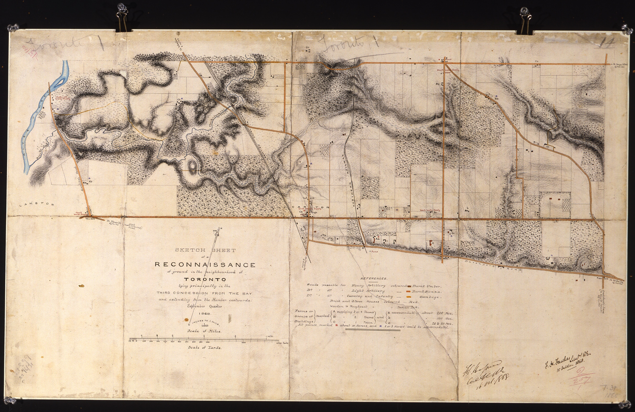
“The land around Fort York was set aside for military use in 1793. By 1812 the area had been reduced somewhat, bounded on the east by an arc marking the 1000-yard range of the fort’s guns, on the west by the present-day Dufferin Street, and on the north, as before, by Queen Street. The reserve was gradually cleared of trees so that the fort could be defended against enemies approaching by land.

By the early 1830s there were plans to move the fort further west; at the same time, the citizens of York were pressing for an addition to the town. The military therefore agreed to survey into building lots and to sell the part of the reserve between Peter Street and Garrison Creek.

Because this was a government-sponsored subdivision, the varied proposals for its layout have all been preserved.

This early proposal (November 1833) centres on a circle surrounded by radiating lots and includes a square and provisions for church and market. Note that the area was planned as a self-contained unit with few road connections to the town.

The properties along the lakeshore and along Lot (Queen) Street had already been sold; the prices and the names of owners were recorded on this plan. Note the higher prices paid for lots along the lake; the area attracted purchasers of a higher social status, in part because of its location near the proposed site for the Government House.”

- Isobel Ganton & Joan Winearls, MAPPING TORONTO'S FIRST CENTURY 1787-1884

Click the image to view a full-size version (PDF). 

Map: Proposed Sketch of an intended addition to the Town of York (Toronto), 1833, Henry James Castle

With the exception of the Lots on the Bay shore and those on Dundas or Lot street coming under the head of Sections A and C this PLAN is merely a Proposed Sketch of an intended addition to the Town of York. His Excellency not having yet decided upon the Internal Arrangements.
H.J. Castle Dep. Survr. Novr. 26th 1833 Survr Genls Dept York. U Canada
(Lithographed by Samuel Tazewell and described in the Patriot 26 Nov 1833)

Image courtesy of Library and Archives Canada: NMC5035
Winearls, MUC no. 2064(2)

“This (following) proposal for the reserve differs dramatically from the previous one. A simple extension of the town grid has replaced the early innovative design. All streets were to be opened and the land was to be divided into rectangular blocks and half-acre lots.

Note that two earlier burial grounds influenced the location of squares on all versions of the proposed subdivision. The cemetery for the military is still in Victoria Square; that for cholera victims on Newgate (Adelaide) Street was soon replaced by St. Mary's Roman Catholic Church.”

- Isobel Ganton & Joan Winearls, ibid.

Click the image to view a full-size version (PDF). 

Map: Government Second Sale of Lots in the City of Toronto May 1834. Commissioner of Crown Lands Office Toronto May 5th 1834. H.J. Castle.

Government Second Sale of Lots in the City of Toronto May 1834. Commissioner of Crown Lands Office Toronto May 5th 1834. H.J. Castle. Dy. Surveyor 5th May 1834. H.W.J.Bonnycastle del.

Image courtesy Toronto Public Library: T1834-2/4Msm. Winearls, MUC no. 2064(6)

Note: In the original MAPPING TORONTO'S FIRST CENTURY 1787-1884 exhibit, the above caption described a different map, Plan of the Proposed New Town in the Late Military Reserve York, U. C. Henry James Castle Feby 20 1834. (Winearls, MUC no. 2064(4).) Unfortunately I don’t have an image for that plan, and so have substituted a slightly later one; the salient points of the commentary apply equally well to the latter. 

For More Maps On This Topic
To view additional maps and history pertaining to the development of the Military Reserve east of Garrison Creek, see here (Fort York and Garrison Common Maps).

Bonus Map
Who doesn’t love bonuses?

In this third plan selected from the blizzard of proposals for the area (there were 18 in total), we can see some familiar street names cropping up. Another tier of lot auctions would shortly be underway.

Map: Plan of lands, lately surveyed, adjacent to Toronto Garrison. Surveyor General’s office, Toronto 17th Novr 1834, Copy – Henry Lizars.

Plan of lands, lately surveyed, adjacent to Toronto Garrison. Surveyor General’s office, Toronto 17th Novr 1834, Copy – Henry Lizars.

Source: Ontario Ministry of Natural Resources, Office of the Surveyor General. SR343 H24
© 2014 Queens Printer Ontario
Winearls, MUC no. 2064(7)


Please ‘Like’ and Share these maps with other Toronto history enthusiasts! (+1s are also welcome!)

1801 Elmsley: Sketch of a part of the Town of York

“Progress in clearing and in building was slow in the New Town. In September of 1800, owners were ordered to clear their land or forfeit their lots. As this survey shows, most owners had complied (lots in blue [& blank -N.]). Those failing to do so owned the less desirable lots (in black) farther from the lake.”

- Isobel Ganton & Joan Winearls, MAPPING TORONTO'S FIRST CENTURY 1787-1884

By early 1801, some 77 lots appear to have been cleared or at least had brush cut. The eastern edge of the New Town began one block east of Yonge, at what is labelled Toronto Street on the map, later renamed Victoria. At the time, Yonge St. did not extend south past Lot (Queen) St.; according to Henry Scadding (cf. Toronto of Old), the roadway there suddenly veered eastward, passing down what we now call Toronto Street, a jogging irregularity marking the most convenient route towards the market.

Click the image to view a full-size version. 

Map from 1801 of part of the Town of York (Toronto)

Sketch of a part of the Town of York ... This seconde Examination done by order of the Honorable John Elmsly [sic] Esquire and performed by [blank] [likely J. Stegmann]Undated, early 1801.

Source: Ontario Ministry of Natural Resources, Office of the Surveyor General, Plan Ref: SR407 H26
Copyright:  2014 Queens Printer Ontario
Winearls, MUC no. 2026 (1)


The next plan shows the progress in clearing the town lots, with 115 lots indicated as being cleared.

Click the image to view a full-size version. 

1801 Map of part of York (Toronto) by John Stegmann

Sketch of the part of the Town of York West of Toronto Street ... this survey made by order of the Surveyor General’s Office bearing date April the 23rd 1801 John Stegmann

Source: Ontario Ministry of Natural Resources, Office of the Surveyor General, Plan Ref: SR387 H26
Copyright:  2014 Queens Printer Ontario
Winearls, MUC no. 2026 (2)

The enforcement of the clearing order is described in this March 6, 1801 correspondence from Justice John Elmsley to Lieutenant Governor Peter Hunter (a transcript from Firth follows for ease of reading):

Part of a letter from Elmsley to Hunter, describing
the enforcement of the order to clear town Lots.
John Elmsley Letter Book 

From The Town of York: 1793-1815, Edith Firth, p54

Please ‘Like’ and Share these maps with other Toronto history enthusiasts! (+1s are also welcome!)

1830 JG Chewett: Plan Shewing the Survey of part of the Park East of the Town of York into 1/2 Acre Lots

“The area from Parliament, Street to the Don River formed the first major extension of the town after 1797. The subdivision south of Queen Street shown here was laid out on behalf of the York General Hospital which had been granted the land in 1819. The names noted are chiefly those of shopkeepers and craftsmen who lived elsewhere in town. Most of them probably purchased these lots as investments. Note the earlier fields and buildings which were ignored in the new survey. Also note the effect that the diversion of King Street to the bridge over the Don River had on the grid plan.”

- Isobel Ganton & Joan Winearls, MAPPING TORONTO'S FIRST CENTURY 1787-1884

Click the image to view a full-size version. 


Plan shewing the Survey of part of the Park East of the Town of York into 1/2 Acre Lots by Command of His Excellency Sir John Colborne Lieutenant Governor &c &c &c By James G. Chewett Surveyor York June 21st 1830.
Coloured manuscript; [1 inch to 2 chains]

Source: Ontario Ministry of Natural Resources, Office of the Surveyor General: SR394 [via Distillery Historic District]
Copyright:  2014 Queens Printer Ontario
Winearls, MUC no. 2059

Please ‘Like’ and Share these maps with other Toronto history enthusiasts! (+1s are also welcome!)

1875 Howard: Map of High Park

In 1836, John George Howard purchased for $1,000 a sprawling 160-acre property to the west of Toronto, extending from Bloor Street down to Lake Ontario. Howard was a successful English emigré and one of the first professional architects in Upper Canada. He was also an engineer and land surveyor. Naming the property “High Park” due to its elevation, Howard then designed and built Colborne Lodge, a Regency-style cottage, as his residence in the south end of the park in 1837 (Sir John Colborne was Howard’s patron and served as Lieut. Governor of Upper Canada).

It is my pleasure to present the following cartographic plan of High Park and surrounding area—drawn by John Howard himself with ink and watercolour on linen. The map dates to somewhere between 1875 and 1890. It illustrates elevations, drainage, names of buildings, property owners, the subdivision of adjoining properties, and other physical features.

Click the image to view a full-size version. 


High Park, John G. Howard, circa 1875 (presumed)
Credit: City of Toronto, Museum Services, 1970.222.19G

Over 700 drawings of Howard’s have been preserved. Howard was also known for his design of the Provincial Lunatic Asylum.

Writing to city officials in 1873, Howard declared he ‘always had a great wish that the park should belong to the city of Toronto as they will require such a place in a few years...”

He then conveyed 120 acres of the property to the City in that year with the proviso that it was ‘for the free use, benefit and enjoyment of the citizens of the City of Toronto forever: and to be called and designated at all times thereafter ‘High Park’’. Some of the other stipulations in the deed included: permitting Howard and his wife Jemima to continue to reside at Colborne Lodge; prohibiting the sale of alcohol in the park; a restriction on the harvesting of timber; and leaving the estate in as natural a state as possible. A minority of city councillors felt that the park was too far away from the core to be of utility, but in the end the City accepted Howard’s gift, granting him a lifetime pension in the amount of $1,200 per annum in exchange. The park was opened to the public in 1876.

The remaining 40 acres of Howard’s were granted to the City upon his death in 1890; in 1876 and 1930 the City also acquired properties to the east (172 acres from Percival Ridout) and west (71 acres from the Chapman estate, formerly Ellis) of the original lands. Later, two more acres were added via the amalgamation of the Village of Swansea; 18 acres were removed for the construction of the Queensway.

High Park continues to serve as the jewel in Toronto’s municipal parklands, a calming sanctuary from our frenetic metropolis.

For more on the early history of High Park and on John Howard, try David Wencer’s Historicist article, John Howard’s Enduring Monument: High Park's transition from private property to public space.

Bonus map
This plan from 1894 shows High Park in the context of Swansea, with a number of proposed electric railways providing easier access.


Diagram showing electric railways connecting Toronto and Swansea | Projected and Constructed
by J. Ellis, 1894.

Image courtesy Toronto Public Library: MsX.12

Please ‘Like’ and Share these maps with other Toronto history enthusiasts! (+1s are also welcome!)

1865 Jervois: Toronto, Canada West, Shewing Existing & Proposed Defences

Lieut.-Col. William F. D. Jervois, ca. 1862
During the 1860s, the British military was seriously concerned by the contingency of war with the United States on colonial soil, particularly in light of the Trent Affair and the American Civil War, in the course of which the Confederacy had invited British intervention over Union blockades.

Lieut.-Colonel William Francis Drummond Jervois (pronounced Jer-vus), of the Royal Engineers, was tasked with creating a plan to deal with an invasion of Canada by American forces. His Report on the Defence of Canada, prepared in February of 1864, dealt primarily with measures for Halifax, Quebec, and Montreal. Jervois believed that outnumbered British and Canadian troops could not victoriously engage the Americans in the open field; a strategy of fortification and delay was consequently in order. He concluded that the lands west of Montreal could not be successfully defended.

Subsequently, Jervois’ purview was nonetheless extended to include Canada West (Ontario). The Hon. William McDougal, Provincial Secretary, wrote to Jervois on October 18, 1864 with a list of additional questions:

“In the event of a war between Great Britain and the United States being seriously threatened, what preparatory steps for defence should be taken by the people of Canada? [Q1] [. . .] Would Toronto be an important point of defence, and if so, what works would be required there, and what would be the probable cost? [Q24]”

Jervois’ summary of the defence of Toronto

Jervois replied on the 10th of November, 1864, with a controversial revised plan that outlined a scheme for the defence of the western districts, in the context of a fortified Harbour at Kingston and a naval force being placed on Lake Ontario. The following rare map, produced in January 1865, shows his proposition for Toronto.

The dotted green line indicates a suggested line of massive earthworks running from Humber Bay to the Don River. A pair of Martello towers would be constructed on the Island for sea defence. Old Fort York was to be discarded; a new battery would instead be constructed at the New Fort (Stanley Barracks). These works together would cost approximately £90,000 in total.

Other details of note:
  • the Eastern Gap, recently created by an 1858 storm
  • the cluster of buildings comprising Yorkville
  • the location of various mills along the upper Don and the Humber.

Worth consideration alongside this map are the related 1868 reconnaissance sketches of the Toronto area prepared by Gehle, Fawkes and Hassard. As a set, these maps provide a strategic military perspective on the city’s topography and resources of value.

Click the image to view a full-size version. 


Toronto, Canada West, Shewing Existing & Proposed Defences 
To accompany Report by Lieut-Colonel Jervois. Dated January 1865
[William F.D. Jervois, Report on the Defence of Canada (Made to the Provincial Government on the 10th November 1864) 
(London, 1865)]

Image from Historical Atlas of Toronto (2009), map 101, by Derek Hayes, reproducing U.K. National Archives MPH 1/1111/1

Concluding his revised report, Jervois wrote: “By means of the measures recommended in this paper, Canada, aided by Imperial troops, would be enabled to resist American aggression with success; and who shall say that, thus tiding over the time of her dependence and comparative weakness, she may not, united with the other provinces of British North America, at length become a great and powerful nation which may hold her own against the world!”

Canadian Confederation would take place in 1867. Jervois would later go on to become the Governor-General of New Zealand in 1883. I definitely recommend reading his reports for a revealing glimpse into a time when the threat of American invasion loomed large.

See also
1868 Gehle, Fawkes & Hassard: Reconnaissance Sketches of Toronto Area

Please ‘Like’ and Share these maps with other Toronto history enthusiasts! (+1s are also welcome!)

1837 Hawkins: Toronto Military Reserve [Feb. 1837]

Starting in 1833, Sir John Colborne oversaw a major expansion westward of the city, with the sale of over 200 acres of the Military Reserve adjoining Fort York east of Garrison Creek, in order to fund the construction of a new fort. The following, final official plan for the area documents the result of that process, and is packed with the names of lot owners and corresponding lot numbers.

Click the image to view a full-size version (PDF). 


Toronto Military Reserve. Resurvey by Wm Hawkins Dy. Surveyor. By order of His Excellency Sir Francis B. Head Lieut. Governor U. Canada &c &c &c as laid out in Town Lots on the east of the Ravine. [Sgd] To the Honble John Macaulay Surveyor General &c &c &c Toronto William Hawkins Dy Surveyor Toronto 18th Feby 1837 [Certified and sgd] R.H. Bonnycastle Captn Royal Engineers Western District U.C. 21st Feby 1837

Source: Ontario Ministry of Natural Resources, Office of the Surveyor General: 348-H24
© 2013 Queens Printer Ontario
Winearls, MUC no. 2064 (15)

See the 1797 Smith Plan for the enlargement of York for the previous major town expansion.

Please ‘Like’ and Share these maps with other Toronto history enthusiasts! (+1s are also welcome!)

1852 Liddy: [I]ncorporated Village of Yorkville in the County of York and Province of Canada

“The generous limits of Yorkville at incorporation show that the boom mentality prevailed even in a village so small that its urban landowners could all be listed on the sides of the map. Different patterns of transitional subdivision are evident along Yonge Street and Avenue Road to the west; these patterns had already begun to determine the location of urban streets.

The map, although somewhat resembling folk-art in the representation of the trees and the brickyard, shows the influence of the British Ordnance Survey in the patterning of fields. Note the early idea for a rectangular plan in part of the Rosedale estate (right centre), soon to be superseded by a dramatically different plan.”

- Isobel Ganton & Joan Winearls, MAPPING TORONTO'S FIRST CENTURY 1787-1884

Click the image to view a full-size version (PDF, 3MB). 

1852 Survey by GP Liddy of the Village of Yorkville

[I]ncorporated Village of Yorkville in the County of York and Province of Canada. 
Drawn from an actual Survey by G.P. Liddy Late of the Engineering Department of the Ordnance Survey of Great Britain and Ireland. Provincial Land Surveyor, Civil Engineer etc. [Sgd] Geo. P. L[iddy]

Source: Ontario Ministry of Natural Resources, Office of the Surveyor General: SR7017
Copyright:  2013 Queens Printer Ontario
Winearls, MUC no. 2091

Yorkville was incorporated January 1, 1853.

Bonus Yorkville maps for comparison
Twenty years on:


Map of the village of Yorkville and vicinity, compiled from plans & filed in the Registry Office and shewing subdivisions in lots 16 to 28 in the second concession from the bay in the Township of York. 1877.
By: Silias James, P.L. Surveyor. Publisher: Copp, Clark & Co. Lith. Toronto

Image courtesy of Toronto Public Library: T1877/5 Large

Note the 'Town Hall' at Yonge and William (Yorkville). Also observe how topography determines the course of Davenport Road.


Map of Yorkville and its vicinity, 1878
By: Alfred T. Cotterell (pub: Ralph Smith & Co.)
From: 1878 Illustrated Historical Atlas of the County of York

Image courtesy of Toronto Public Library: T[1878]/4Msm

Note the City Reservoir (Rosehill), constructed in 1873/4.

Please ‘Like’ and Share these maps with other Toronto history enthusiasts! (+1s are also welcome!)

1868 Gehle, Fawkes & Hassard: Reconnaissance Sketches of Toronto Area

‘These reconnaissance maps were made to help the military to meet the threat of raids by the American-based Fenians on Toronto, now the capital of the new Province of Ontario. The military nature of the maps is evident (see "References") in the type of information recorded: roads passable for artillery, farms able to supply horses and to accommodate soldiers, and sources of fresh water.

These maps are the first to show the topography of the region in detail. They reveal the close relationship between river valleys and uncleared land. The routing of roads around physical barriers is clear as well.

Although most major buildings are shown, only those important to the military, such as the taverns and hotels along the roads out of town, are identified. A few industrial sites, such as the brickyards along Kingston Road and in Yorkville, are also noted.

Two Royal Engineers produced this set of maps. The difference in their styles is evident...’

- Isobel Ganton & Joan Winearls, MAPPING TORONTO'S FIRST CENTURY 1787-1884

Click the images to view full-size versions (PDF). 


Sketch Sheets of a Winter Reconnaissance of the Country W. of Toronto to the Humber River, and North to the Davenport Road
[Surveyed by:] H.J.W. [Henry John Wolsteyn] Gehle, Lt. R.E. 11/1/68
[Signed] F.C. [Fairfax Charles] Hassard, Lt. Col. 15/1/68

Image courtesy of Library and Archives Canada: NMC20712

Note in the above map the Sandy beach, good landing for boats (Americans landed here in 1812).


Sketch Sheet of a Reconnaissance of Ground in the neighbourhood of Toronto lying in the 2nd and 3rd Concessions from the Bay, east and west of Yonge Street. December Quarter 1868

[Surveyor:] F.H. Fawkes, Lt. R.E. 22.1.69
[Signature] F.C. Hassard, Col. R.E. 26.1.69

Image courtesy of Library and Archives Canada: NMC20710


Sketch Sheets of a Winter Reconnaissance of the Country East of Toronto, between the Don River; & the Township of Scarboro, on the E. & the Don & Danforth Road. on the N. to the Lake Shore. Office Copy - original to Montreal, 20 Apl. 68. 
[Surveyor:] H.J.W. Gehle, Lt. R.E. 17/Apl. 68.

Image courtesy of Library and Archives Canada: NMC20711


Sketch of a Reconnaissance of ground in the neighbourhood of Toronto being the Eastern extremity of the 2nd and 3rd Concessions from the Bay  [This map is essentially the eastern continuation of NMC20710 above. -N.]

Surveyed by: F.H. Fawkes, Lt. R.E., June Quarter 1869.
F.C. Hassard, Lt. Col. R.E. 20 August, 1869.

Image courtesy of Library and Archives Canada: NMC22847 [via Derek Hayes’ Historical Atlas of Toronto]


Sketch Sheet of a Reconnaissance of ground in the neighbourhood of Toronto lying principally in the Third Concession from the Bay and extending from the Humber Eastward. September Quarter 1868

[Surveyor] F.H. Fawkes, Lt. R.E. 15 Oct 1868
[Sgd] F.C. Hassard 16 Oct 1868

Image courtesy of Library and Archives Canada: NMC22845 with assistance from Ed Dahl and City of Toronto, Culture Division


Bonus: Etobicoke


Toronto District Sketch Sheets of a Reconnaissance of the Country between the rivers Humber and Etobicoke from the shore of Lake Ontario to Dundas Street on the North.  1867. [Sgd] H.J.W. Gehle, Lt. R.E., 16/7/67

Note: Unfortunately the only high-resolution scan available is in black and white. If you'd like to pay for a colour scan, let me know.
Colour Thumbnail courtesy Library and Archives Canada: NMC26685
B&W expanded Scan courtesy University of Toronto Map and Data Library: NMC26685


Sketch Sheets of a Reconnaissance in the County of York, Township of Etobicoke, between the Humber & Etobicoke Rivers, N. of Dundas Street 
[Sgd] H.J.W. Gehle, Lt. R.E. 16/10/67.

Image courtesy University of Toronto Map and Data Library: NMC26681. [LAC record: NMC26681]

See also
1865 Jervois: Toronto, Canada West, Shewing Existing & Proposed Defences

Please ‘Like’ and Share these maps with other Toronto history enthusiasts! (+1s are also welcome!)

1859 University of Toronto Campus / Queen’s Park [Plan of the University Park]

The University of Toronto / King’s College / University College
‘The university land had been little developed since its purchase in 1829 [by Bishop Strachan]. King’s College ['The Asylum', lower right] had been built in 1842, but was later used as a lunatic asylum. In 1854 the eastern part of the site (now Queen’s Park) was proposed as the location for new provincial parliament buildings [but nothing was built until 1886; see 2nd map below. -N.].

University College was opened in 1859 and some of the curving drives were added in that year. Taddle Creek, prominently shown in the middle, was polluted with sewage from Yorkville by the 1870s and remained a bone of contention between city and university until it was covered over in the 1880s.’

- Isobel Ganton & Joan Winearls, MAPPING TORONTO'S FIRST CENTURY 1787-1884

Click the image to view a full-size version. 


Campus Map of area bounded by College, St. George, Bloor and Surrey Place [Plan of the University Park], c. 1859
Map courtesy of: University of Toronto Archives, 2003-42-3MS [A1965-0001(20)]
Winearls, MUC no. 2103 (2)

Queen’s Park
In 1854 the eastern portion of the university lands was the proposed location for the new legislature buildings, as reflected in this earlier map by John Stoughton Dennis (see next) showing nearby lots for sale from the Denison estate. It was then hoped that Toronto would be chosen by Queen Victoria as the permanent capital of the Province of Canada. Due to a lack of funds (and Toronto being passed over in favour of Ottawa), the depicted plan by Cumberland and Ridout for the Parliament Buildings “about to be erected” was never built.

Click the image to view a full-size version. 


Plan of Part of the City of Toronto Shewing the Town Lots on Bellevue For Sale by the Trustees for the Denison Estate March 1854
John Stoughton Dennis P.L.S. Maclear & Co. Lith. Toronto
Map courtesy of Toronto Public Library: T1854/4Msm
Winearls, MUC no. 2105

In 1859 the University leased 49 acres—an area encompassing the present day Ontario Legislature, parts of the modern day university campus, and portions of College Street and University Avenue—to the City of Toronto for a period of 999 years, to create a public park. Queen’s Park was officially opened by the Prince of Wales on September 11, 1860.

It would take decades to revive the notion of erecting legislature buildings on the site [see next map]. In 1880, the southern portion of the Park was turned over to the Province of Ontario for construction. Observe how the former King's College building, used as the 'University Lunatic Asylum' until 1869, is now merely labelled 'Old Building to be Removed'.

Click the image to view a full-size version. 


Site of the proposed parliament buildings, Ontario. Queen's Park.
Department of Public Works, Ontario. Toronto, April 7, 1880
Map courtesy of Toronto Public Library: T1880/4Mlrg

Supplementary Photos — View from University College
I came across this set of four remarkable photos taken in 1859 by William Notman, from the top of University College. The views they depict correspond to a large section of the 1859 map of the campus.

Looking east from University College to King’s College/
the University Lunatic Asylum

Looking south east to the Moss Hall (the Medical Building).
The closer structure is the residence of George Kingston,
the Director of the Observatory.

Looking south to the Magnetic Observatory (in its original location)

Looking north towards Yorkville

Reference: see E 9-277 and E 9-278. Note: I only confirmed the provenance for these two photos, but am inclined to believe that the other two are also Notman’s. Please let me know if there is evidence to the contrary!

Bonus Map — 1852 Exhibition Grounds
The following map shows the Exhibition Grounds in 1852,  located that year a little south of Queen’s Park along the west side of College Avenue (a.k.a. University).


Sketch of the Exhibition Grounds, Toronto
Lithograph by S.A.F. in Canadian Journal v.1, no.3 (October 1852) facing p. 49.
Map courtesy of Toronto Public Library: JRR 3539

Further reading on Queen’s Park:
Queen’s Park - Via Ontario Heritage Trust.

Please ‘Like’ and Share these maps with other Toronto history enthusiasts! (+1s are also welcome!)

1817 Smith: Plan of York, U.C. & 1818 Plan of the Town of York

This military reconnaissance map of York was surveyed and drawn by Lieut. E.A. Smith of the 70th Infantry, and provided to Sir John Coape Sherbrooke, the Governor General of British North America at the time (via the Quartermaster General’s Office, Upper Canada).

Numerous key structures are noted, including the Garrison, Gibraltar Point Lighthouse, the Government House, and the ravine Blockhouse (roughly where Trinity Bellwoods Park is). As well, the estates of several leading citizens are indicated. The Smith map was part of a historically significant collection of Sherbrooke’s papers purchased at auction in June 2013 by Library and Archives Canada. It is my hope that at some point the map will be scanned in high resolution.

Click the image to view a full-size version. 


Plan of York, U.C. / Surveyed and Drawn August 1817, by Lieut. E.A. Smith, 70th Inf'y E.A. Smith pinxit
Image courtesy of Library and Archives Canada

Another, later version of this map was prepared by Smith for Sherbrooke’s successor, Lord Dalhousie (George Ramsay). Slightly smaller in coverage than the 'Sherbrooke' iteration, this plan is worth scrutiny as there are a small number of subtle differences that invite further reflection.

Based on the indication of Chief Justice William Campbell’s residence (Campbell House, at the head of Frederick on Duke Street), it is likely that this copy was created around 1821-1822 or after (Campbell purchased the land in 1821; the residence was built in 1822).

Click the image to view a full-size version. 


Plan of York. Surveyed in 1817 by Lieut. Smith 70th Regt. E. A. Smith pinxit

Image courtesy of Acadia University, William Inglis Morse Collection: Accession no. 1931.004-WIM/58
Winearls, MUC no. 2041

Note: The Morse Collection label, bottom left, is slightly incorrect, as Lord Dalhousie was appointed Governor-in-chief of British North America in April, 1820.

The Smith maps should also be compared with the two Williams plans, and the 1818 Phillpotts Plan of York.

Supplement
The next plan from 1818 shows the names of lot owners for the town, including park lots.

Click the image to view a full size version.


Plan of the Town of York W.C. [9 June 1818]
Image courtesy Toronto Public Library: T1816-3/4Mlrg. Winearls, MUC no. 2044

The names are interesting to contrast with those found on the [David] Smith plans for the enlargement of York, two decades previous—some names have changed, while others remain the same.

Please ‘Like’ and Share these maps with other Toronto history enthusiasts! (+1s are also welcome!)

1886 Wesbroom: City of Toronto [Bird’s Eye View]

“This bird’s eye view [...] shows more clearly than either maps or streetscape photographs the congestion of the downtown core and the unrelenting zeal with which the grid pattern of streets—first laid out for Simcoe in 1793—had been stretched across the landscape on either side of the arrow-straight line of Yonge. Standing out against this pattern are the few attempts to mitigate the worst aspects of the grid plan: natural changes like King Street / Kingston Road, which turns northeast on the right side of the view; the carefully planned avenues like Spadina (with its crescent at the north end) and University; and the park-like green spaces scattered throughout the city [...]

If proof were needed that the Victorians, just as much as the Georgians, were proud and capable city builders, this bird’s eye view provides it amply. A celebration of their creation, it is a lasting testimony of what had been created in Toronto.”

- William Dendy, Lost Toronto

Click the image to view a full-size version. 


City of Toronto
Lithograph by William Nathaniel Wesbroom, 1886 (? see note on dates below)
Toronto Lithographing Company

Image courtesy Ben Hammer/Cartographics. A handmade set of prints based on the Wesbroom lithograph may be purchased from Mr. Hammer here.

The above image is that of the copy held by the Thomas Fisher Rare Books Library at U of T: G3524 .T61 1886. As you can see it has suffered some folding damage and has a few small chunks missing out of it — but it is otherwise at an excellent resolution and you may find yourself poring over the details for quite some time...

The TPL possesses in its archives a more pristine copy (CHPC accession number 975-29 Cab III), which has not been scanned to date [edit: see update below]. I was able to view it in person and took the following somewhat muddy, lower-resolution photograph of the print:

City of Toronto [Bird’s Eye View], 1886, W. Wesbroom

City of Toronto
Lithograph by W. Wesbroom, 1886 (? see note below)
Toronto Lithographing Company

[UPDATE Nov. 2014: The TPL has since done a scan, but I have not been able to obtain a high-resolution version.]

Note regarding dates: Dendy’s Lost Toronto — which uses this bird’s eye view as its cover — gives an approximate date of 1878. Derek Hayes’ Historical Atlas of Toronto indicates 1884. And the catalogue info at the Thomas Fisher Rare Books Library indicates a date of 1886. These may be slightly different prints, or they may be the same and there just isn’t agreement on the actual date...


The Toronto Lithographing Company seems to have done especially fine work, wouldn’t you say?

1886 Globe advertisement for Wesbroom Bird's Eye View of Toronto map
Advertisement: The Globe, May 22, 1886 
The Osborne Collection at the Toronto Public Library (Lillian H. Smith branch) features this cropped jigsaw puzzle of the map in their Canadiana holdings:

Wesbroom Bird's eye view of Toronto: jigsaw puzzle

Lovely.

See Also [Bird’s Eye Views]
1870 Canadian Railway News Bird’s Eye View of Toronto
1876 PA Gross Bird's Eye View of Toronto
1876 Gascard City of Toronto Bird’s Eye View from the Northern Railway elevator
1892 Toronto Railway Company Map Shewing Toronto Street Railway Lines
1893 Barclay, Clark & Co. Bird’s Eye View Chromolithograph

Please ‘Like’ and Share these maps with other Toronto history enthusiasts! (+1s are also welcome!)

1791 Jones: An accurate Plan of a Survey [...] of the River Trent (head) [North shore] of Lake Ontario to Toronto

“This important survey by Augustus Jones established the eastern sideline (now Victoria Park Avenue) and the baseline (now Queen Street) for Dublin (York) Township. The township lines formed the basic framework for all later development and thus determined the eventual northwest-southeast orientation of Toronto. The survey recorded here began 90 miles east of Toronto at the Bay of Quinte and laid out the fronts of 11 townships between there and York. Wherever possible, the baselines of townships were laid out parallel to the lake shore.”

- Isobel Ganton & Joan Winearls, MAPPING TORONTO'S FIRST CENTURY 1787-1884

Note that York township was briefly named Dublin (and Scarborough, Glasgow), prior to Simcoe’s arrival in 1793. It is likely Surveyor General Andrew Russell who wrote in the revised name in 1856.

Click the image to view a full-size version. 

An Accurate Plan of a Survey [from] the River Trent, North [Shore] of Lake Ontario to Toronto by Augustus Jones, 1791

An accurate Plan of a Survey [words missing] of the River Trent (Head) [words missing - North shore?] of Lake Ontario to Toronto [words missing] by Augustus Jones, 1791.
Source: Ontario Ministry of Natural Resources, Office of the Surveyor General, Plan Ref: SR5803 O6-4
Copyright:  2013 Queens Printer Ontario
Winearls, MUC no. 316

The above detail shows only the westerly York portion. View the entire map here (note: it’s quite long horizontally!).

The following, slightly more detailed survey of Dublin by Jones, was a copy made by John Frederick Holland. The horizontal 'front line' line is what later became Lot (then Queen) Street. ‘Toronto Fort’ indicates the location of Fort Rouillé.

I’m curious what that peninsula south of lot 23 is supposed to be.

Click the image to view a full-size version (PDF).

Plan of Eleven Townships fronting on Lake Ontario beginning at the River Trent and extending westerly to Toronto, Augustus Jones, 1791

York Home Dist. 'Township of Dublin' 'Y30' - Plan of Eleven Townships fronting on Lake Ontario beginning at the River Trent and extending westerly to Toronto as laid out and surveyed by Augustus Jones Dy PL Survr, A true copy by Jn Fk Holland [Sgd] Samuel Holland Surveyr Genl, 1791.

Image courtesy of Ontario Ministry of Natural Resources, Office of the Surveyor General, Plan Ref: 2391 K25
Winearls, MUC no. 316 (2.1)

Augustus Jones (circa 1763-1836) was a Loyalist. He was appointed a Deputy Surveyor in 1791 and was responsible for the survey of most of York Township, Yonge Street, part of Dundas Street, the new part of the town of York, and many townships east of Toronto and in the Hamilton area. He did little surveying after 1799, but retired to his land, marrying the daughter of a chief of the Mohawks.”
- Ganton/Winearls, ibid.

Please ‘Like’ and Share these maps with other Toronto history enthusiasts! (+1s are also welcome!)