
 |
| Sandford Fleming Image courtesy LAC, C-001164 |
- TPL, All Aboard Toronto
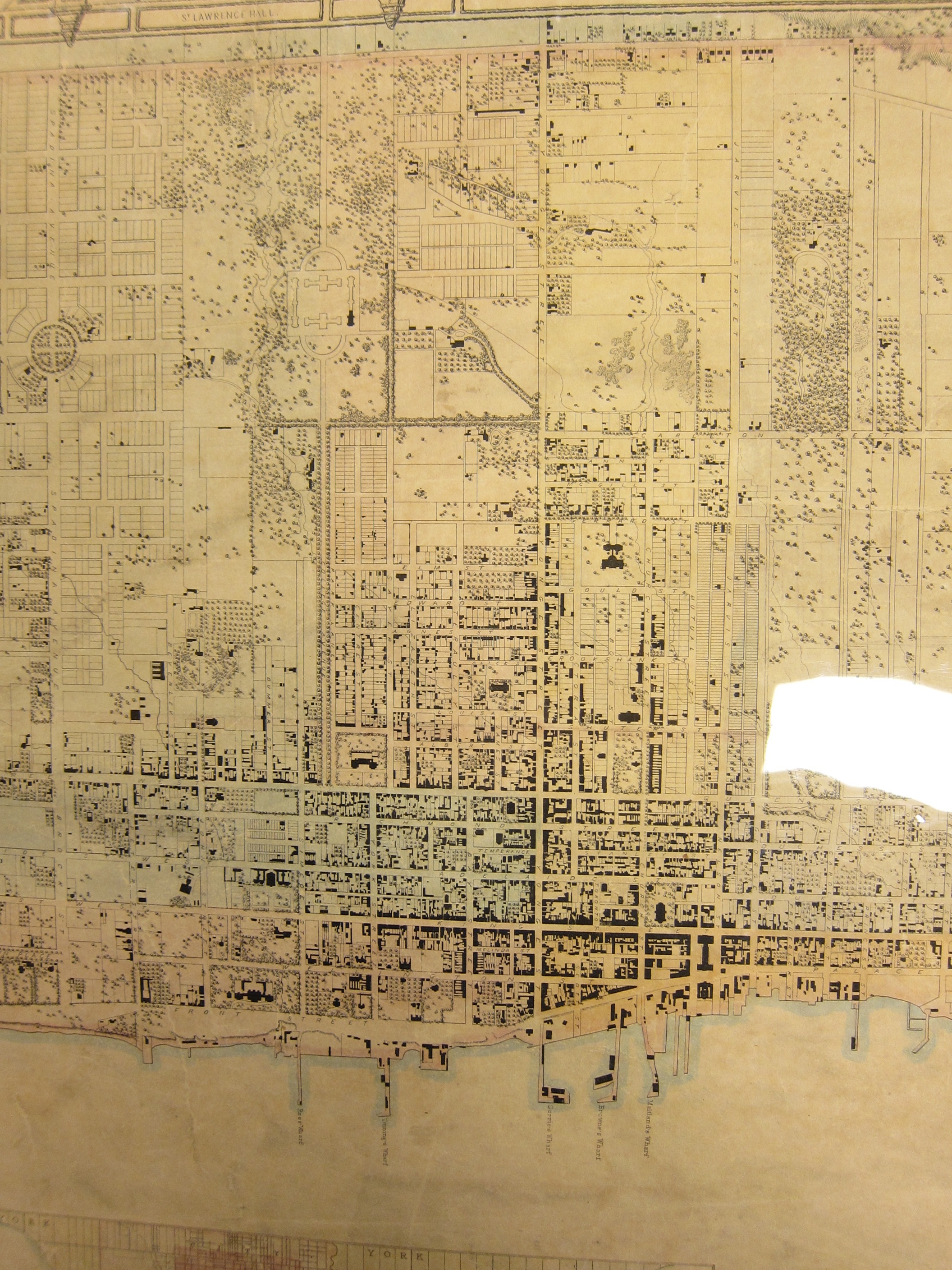
‘Despite a doubling of population in the nine years since the 1842 [Cane] map was made, Toronto had not expanded much in physical area. New building had mainly extended the area of the compact urban core. The university land to the west and the large estates to the east channeled growth up Yonge Street. As in the 1842 map, the views in the border are of churches, banks, and other institutions that suggest the building of a sober and stable society.’
- Isobel Ganton & Joan Winearls, MAPPING TORONTO'S FIRST CENTURY 1787-1884
Click image to view full-size version (5 MB).

TOPOGRAPHICAL PLAN OF THE CITY OF TORONTO, IN THE PROVINCE OF CANADA, From actual Survey, by J. STOUGHTON DENNIS, Provin’l. Land Surveyor. Drawn and Compiled by SANDFORD A. FLEMING, Provin’l. Land Surveyor. 1851. // THIS PLAN IS MOST RESPECTFULLY DEDICATED TO THE WORSHIPFUL THE MAYOR, ALDERMEN, AND COMMONALTY OF THE CITY OF TORONTO, BY THE AUTHOR. PUBLISHED BY HUGH SCOBIE, ADELAIDE BUILDINGS, KING STREET EAST. TORONTO. Engraved on Stone by Sandford A. Fleming, Land Surveyor, 67, Yonge St.
Lithograph, colour; backed with linen. 12 chains to one inch
Image courtesy of Toronto Public Library: T1851/4Mlrg. Winearls, MUC no. 2090
[The catalogue copy is a lower resolution. Ahem. -N.]
In hopes of securing a better image, I took a trip to the Toronto Reference Library to examine the map in person, at the Baldwin Room. I took photographs, but the copy is kept inside a plastic protective sleeve, resulting in horrible glare; hence the odd angles and white splotches. Nevertheless, the fine engraving details are a delight to take in:

Click images to view full-size versions.


Inscription: ‘This plan is most respectfully dedicated to the worshipful the mayor, aldermen, and commonalty of the city of Toronto, by the author. Inset: The harbour of Toronto and adjoining coast. Includes engravings of principal buildings in margins (list of bldgs. on back of page). Includes index to public buildings and index to places of worship.’
Surveyor: John Stoughton Dennis (1820-1885)
Publisher: Hugh Scobie
Drawn & Compiled by: Sir Sandford Fleming (1827-1915)
‘John Stoughton Dennis (1820-1885) became a Provincial Land Surveyor in 1842. He was responsible for the surveying of more than 25 subdivisions in Toronto including the curvilinear plan for Rosedale which may have been his idea and for the training of many young surveyors in the 1840s and 1850s. He became Surveyor General of Canada in 1871.’ (Ganton/Winearls)

Hugh Scobie was an energetic Scotsman who published a newspaper, The British Colonist out of a book and stationery store at 16 King E. in Toronto. He listed his services as: “Bookseller, and stationer, printer, bookbinder, lithographer, copperplate and woodengraver.”
This business eventually later became Copp, Clark & Co., which published the 1876 P.A. Gross Bird’s Eye View of Toronto.
During the preparation of this map over the course of 1850, Scobie expressed dissatisfaction with Fleming’s pace on the project, and conflict arose over payment. A major source of tension was the attribution: in an early version, Sandford Fleming was uncredited.
‘I have no heart to go on with the map unless I get credit for my work. If I don’t choose to finish it, send down the storm,’ wrote Fleming. [Sir Sandford Fleming: His Early Diaries, 1845-1853]
In the end the dispute was settled, and Fleming’s name appears thrice on the map.
Bonus Map - 1852 Military Reserves Boundaries
Fleming also worked on the following ‘Verification Plan’, which is too interesting not to share as a bonus:
Click image to view full-size version (PDF).

Verification Plan shewing the Boundaries as marked on the ground of the Military Reserves belonging to the Ordnance in the City of Toronto, County and Township of York, Canada West as surveyed by Mr. Sandford Fleming Provincial Land Surveyor between the months of November 1851 & May 1852 and verified by Lieut. Berdoe A. Wilkinson, Royal Engineers and Mr. Nelson Walker. Survr. Draftsn. Royal Engineer Depart. 1852.
Image courtesy Library and Archives Canada: MIKAN 4138834. [See also U of T Map and Data Library.]
Another version by Fleming: LAC MIKAN4138833 [At U of T].
See Also: 1857 Fleming Ridout & Schreiber Plan of the City of Toronto
Please ‘Like’ and Share these maps with other Toronto history enthusiasts! (+1s are also welcome!)
During the preparation of this map over the course of 1850, Scobie expressed dissatisfaction with Fleming’s pace on the project, and conflict arose over payment. A major source of tension was the attribution: in an early version, Sandford Fleming was uncredited.
‘I have no heart to go on with the map unless I get credit for my work. If I don’t choose to finish it, send down the storm,’ wrote Fleming. [Sir Sandford Fleming: His Early Diaries, 1845-1853]
In the end the dispute was settled, and Fleming’s name appears thrice on the map.
Bonus Map - 1852 Military Reserves Boundaries
Fleming also worked on the following ‘Verification Plan’, which is too interesting not to share as a bonus:
Click image to view full-size version (PDF).
Verification Plan shewing the Boundaries as marked on the ground of the Military Reserves belonging to the Ordnance in the City of Toronto, County and Township of York, Canada West as surveyed by Mr. Sandford Fleming Provincial Land Surveyor between the months of November 1851 & May 1852 and verified by Lieut. Berdoe A. Wilkinson, Royal Engineers and Mr. Nelson Walker. Survr. Draftsn. Royal Engineer Depart. 1852.
Image courtesy Library and Archives Canada: MIKAN 4138834. [See also U of T Map and Data Library.]
Another version by Fleming: LAC MIKAN4138833 [At U of T].
See Also: 1857 Fleming Ridout & Schreiber Plan of the City of Toronto
Please ‘Like’ and Share these maps with other Toronto history enthusiasts! (+1s are also welcome!)