 |
| Alpheus Todd ca.1867 |
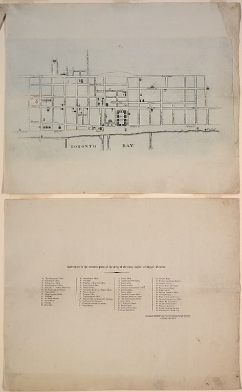
When he was still a young boy, his family emigrated to York, Upper Canada in 1833. The following year, York was incorporated as the city of Toronto. Todd -- at the precocious age of 13 -- produced the following Engraved Plan of the City of Toronto, by walking through the streets and converting his paces to a scale.
‘A member of the local legislature [prominent lawyer Robert Baldwin Sullivan. -N.] was so pleased with the lad’s intelligent pertinacity that he obtained a vote of the House to take copies of the map sufficient to pay the cost of engraving, and had him installed in a temporary capacity in the legislative library [viz., the library of the House of Assembly of Upper Canada. -N.], then a mere nucleus of a collection in a small room.’
- Editor’s Preface, Parliamentary Government in the British Colonies [Alpheus Todd]
Todd’s stellar career as a librarian was thereby launched... But back to the map: it provides the location of over fifty assorted places of interest in the newly incorporated city. The copy seen below, held in the collections of the Toronto Public Library, is believed to be the only surviving copy. The TPL obtained the map via the Stephen A. Heward Family.
Could you draw such a map at 13?
Click the image to view a full-size version.
Plan of the City of Toronto, Capital of Upper Canada, by Master Alpheus Todd, No. 35 Newgate Street, Toronto, Opposite the Brewery, 1834.
Image courtesy Toronto Public Library: T1834/4Msm. Winearls, MUC no. 2067
Amusingly, the Brewery opposite which Master Alpheus lived does not appear to be marked on the map...
Gratuitous bonuses — images of the Town concurrent with the Map
Third Parliament Buildings, by J.G. Howard, 1834.
Front St. W., looking n.w. from Front & Simcoe Sts, labelled ‘S’ on Todd’s map:
Image courtesy TPL: JRR 826
Immigrant sheds are depicted extreme left (source). One of the white buildings in the distance is probably York Hospital -- next picture. See also: Nathaniel Currier—Parliament Buildings, 1835.
Pencil Sketch of Old Hospital, King St. W., n.w. corner John St. built in 1819, Unknown, 18??.
North west corner of King and John St., labelled ‘I’ on Todd’s map.
Image courtesy TPL: B 1-36b
Built ca. 1820, abandoned as a hospital in 1854, this building was also used as a meeting place for Parliament, 1824-1829.
Upper Canada College by Nathaniel Currier, 1835.
Labelled ‘H’ on Todd’s map.
Image courtesy TPL: JRR 3666 Cab II (See also: X 76-61 Cab II)
North side of King Street, Toronto to Church Streets by J.G. Howard, 1835
Image courtesy City of Toronto, Toronto Culture, Museums and Heritage Services 1978.41.40.[1970.114.19A]
K, U, L, J on Todd’s map. (Gaol, Fireman’s Hall, Courthouse, St. James’ church pre-steeple — Todd switched K, L)
See also: Thomas Young, King St. E., looking e. from Toronto St., 1835
Taylor’s Wharf, by J.G. Howard, 1835
Image courtesy City of Toronto Toronto Culture, Museums and Heritage Services, 1978.41.51.
The end of Taylor’s Wharf at the foot of Frederick, looking east. Far right is William Gooderham’s Windmill -- before the distillery was added [Both Taylor’s Wharf and the Windmill may be found on Todd’s map]. To the west of it, one of these structures may be Gooderham’s first house.
[See also...]
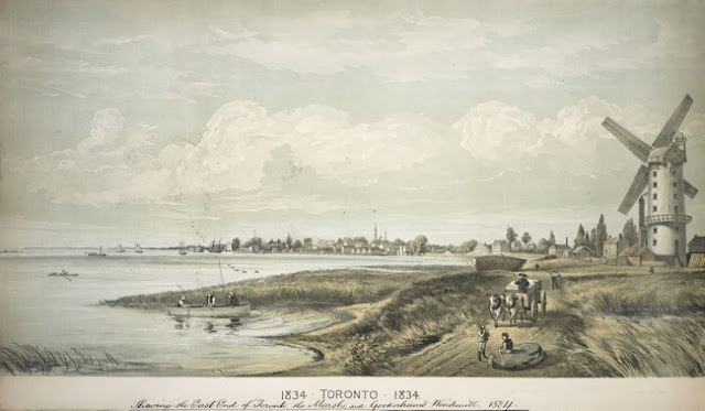
Toronto, 1834. Shewing the East End of Toronto, the Marsh, and Gooderham’s Windmill
Image courtesy Toronto Public Library: B 3-20a
After a lithotint, ca 1877 (979-19-1), which in turn is after a view of Toronto in 1835 drawn by Thomas Young and published by N. Currier in 1835 (x 24-1).
The Windmill is indicated bottom right in Todd’s map.
One More Extra Fun Bonus
This imaginative rendering of the City of Toronto in 1834 was probably created to celebrate the 100th anniversary of the City's incorporation in 1934. Though I can’t vouch for the accuracy of the sketch, it is quite entertaining to compare the notations with those of Todd’s map.
Click the image to view a full-size version.
City of Toronto in 1834 by E.G.A. Foster ca. 1934
Image courtesy City of Toronto Archives: MT 00063
Please ‘Like’ and Share these maps with other Toronto history enthusiasts! (+1s are also welcome!)


