
The low annual rental values assigned by Wilmot during his survey show his poor opinion of the lots. The plan was never implemented. In 1819 the area was granted to the new hospital (forerunner of Toronto General Hospital) to provide it with a source of income.
Note that King Street angled to the north in order to cross the Don River at a good bridging point - a path which it still follows.’
- Isobel Ganton & Joan Winearls, MAPPING TORONTO'S FIRST CENTURY 1787-1884
Click the image to view a full-size version.

A Plan Shewing the Survey of the land Reserved for Government Buildings, East end of the Town of York, Surveyed by Order of His Excellency, Francis Gore, Esquire, Lieutenant Governor &c bearing date the 18th day of Decr. 1810. Feby 25 1811 [Sgd] Saml S[treet] Wilmot Dy Surveyor.
Source: Ontario Ministry of Natural Resources, Office of the Surveyor General: SR390 H26
Copyright: 2013 Queens Printer Ontario
Winearls, MUC no. 2033
See also: this subsequent copy of the plan, via Library and Archives Canada.

The following version is a copy created for J. Ross Robertson’s Landmarks of Toronto (may be a little clearer to read).
Click the image to view a full-size version.

A Plan Shewing the Survey of the land Reserved for Government Buildings, East end of the Town of York, Surveyed by Order of His Excellency, Francis Gore, Esquire, Lieutenant Governor &c bearing date the 18th day of Decr. 1810. Feby 25 1811 [Sgd] Saml S[treet] Wilmot Dy Surveyor.
Image courtesy Toronto Public Library: T1811/4Mlrg
‘The early surveyors were a small group of government employees who, under very difficult conditions, made the surveys of townships, townsites, and roads, so that settlement in Upper Canada could commence in an orderly manner.
For each survey, the Surveyor-General issued instructions which indicated the point where the survey was. to begin and the locations and bearings. of previously surveyed lines. The instructions also covered the dimensions of lots and road allowances and the planting of boundary posts.
The surveyor was required to keep careful field notes indicating each step of the survey and to record all measurements, as well as information on soils, types of trees, rivers, swamps, potential mill sites, squatters, and so on.
On completion of the survey, the surveyor was required to prepare a plan at one inch to 20 or to 40 chains, and to turn this in to the Surveyor-General along with his field notes. Many of the plans were later used to record the names of the settlers to whom land was allotted.
The basic instruments used by the surveyor were a circumferentor compass for sighting along the surveyed line, and a Gunter's chain for measuring the line (100 links in 1 chain equals 66 feet). A few surveyors had better instruments, such as a theodolite, which could be used for measuring horizontal and vertical angles.
There were many inaccuracies in the early surveys because the instruments were not precise, the terrain was rugged, and there was pressure on the surveyor to complete surveys quickly. In addition, the surveyors were not required to be trained and only some had a background in surveying or a knowledge of mathematics.’
- Ganton/Winearls, ibid.
Bonus Map for comparison
This sketch shows the first proposal for laying out lots east to the Don. The base plan was probably copied from those Stegmann made in 1799-1800. Note John Scadding’s land.
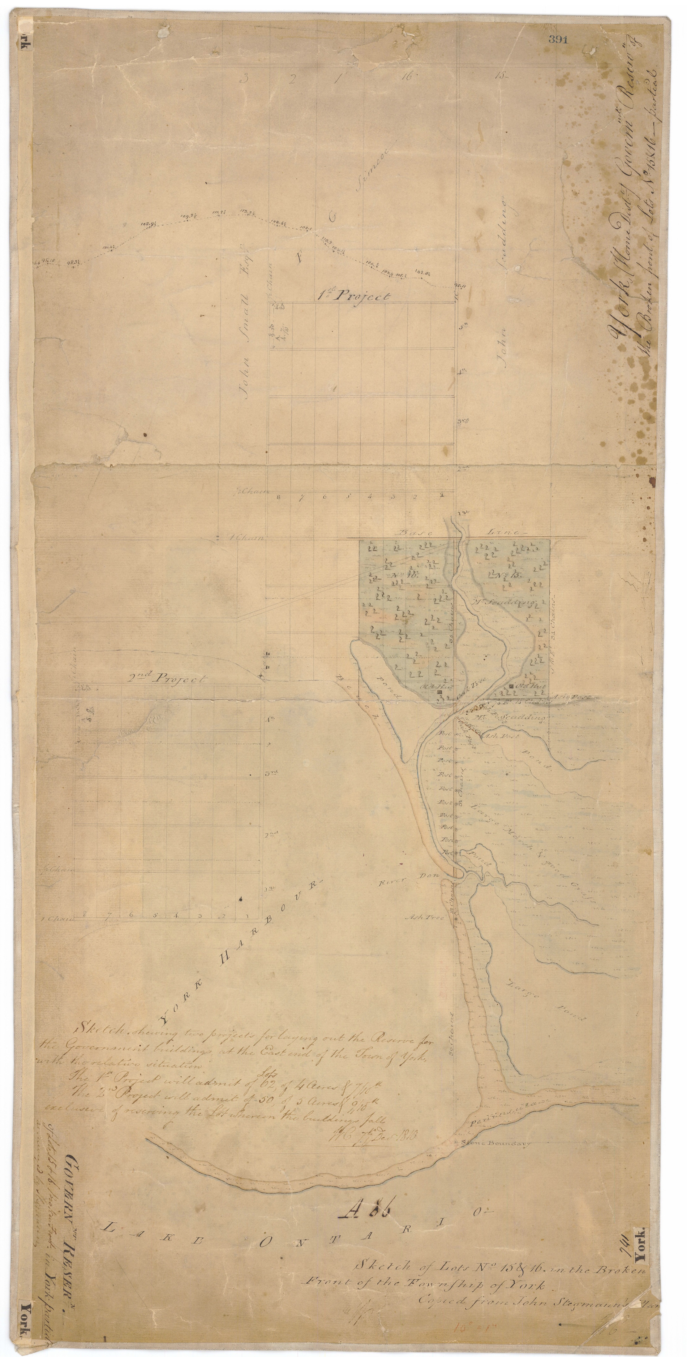
Sketch of Lots No 15 & 16 in the Broken Front of the Township of York. Copied from John Stegmann's Plan. W.C. [and] Sketch shewing two projects for laying out the Reserve for the Government Buildings at the East end of the Town of York with the relative situation ... W.C. 7th Decr 1810.
Source: Ontario Ministry of Natural Resources, Office of the Surveyor General: SR391 H26
Copyright: 2013 Queens Printer Ontario
Winearls, MUC no. 2032
Please ‘Like’ and Share these maps with other Toronto history enthusiasts! (+1s are also welcome!)