York was still essentially a village and had grown little since 1813, an indication that the area set aside for the town was for many years too big for the population.
To the north of Queen Street the small amount of clearing and settlement followed the streams and the narrow rectangular shape of the park lots.’
- Isobel Ganton & Joan Winearls, MAPPING TORONTO'S FIRST CENTURY 1787-1884
“Phillpott's map of Toronto may be considered one of the city's fundamental maps. The map graphically shows the development within the original city blocks as well as the newer developments to the west and north. The map bears the stamps of the Board of Ordnance and the Inspector General of Fortifications.”
- Library and Archives Canada description
Click the image to view a full-size version (PDF).
Plan of York Surveyed and Drawn by Lieut. Phillpotts, Royal Engineers.
Map courtesy Library and Archives Canada: NMC 17026. Winearls, MUC no. 2040 (2)
‘George Phillpotts was a lieutenant in the Royal Engineers, when he made the fine 1818 map of Toronto. He was appointed aide-de-camp to Sir John Colborne in 1833 and was assistant Quartermaster General during the 1837 Rebellion.
The Royal Engineers were stationed in Toronto from the earliest period of British settlement and made reconnaissance sketches and topographical maps for the defense of Toronto as well as plans of the fort and military property. Unlike the civilian surveyors who were primarily concerned with property lines and boundaries, the military were more interested in the shape of the land and location of forested or cleared lands, passable roads, buildings, and other landmarks. Some of their maps of Toronto were the most detailed produced at the time.’ - Ganton/Winearls, ibid.
The following copy of the map was possibly done in 1907 (see archivist’s note, bottom left).
Click the image to view a full-size version (5 MB).
Original image scan courtesy City of Toronto Archives: MT 109. Large version liberated by W. Xavier Snelgrove. See also the version posted by U of T.
For contrast, here is a third, differently coloured and lettered copy of the Phillpotts plan (it appears to be the most recent -- note 'copy of Stamp'):
Click the image to view a full-size version.
Image courtesy Toronto Public Library: T1818-2/4Mlrg
Bonus
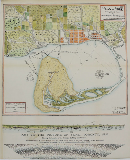
Here’s an almost cartoony version, created for J.R. Robertson’s Landmarks of Toronto:
Bonus #2
A copy of Phillpotts’ plan was done in 1833 without buildings, with some notes on acres within parts of the military reserve, and a few roads in the western part of town added:
Plan of York U.C. Surveyed and Drawn by Lieut Phillpotts Royl Engineers. Copy by J.G. Chewett [Sgd] S.P. Hurd S.G.
Image courtesy University of Toronto Map and Data Library: NMC 22824. Winearls, MUC no. 2062
Please ‘Like’ and Share these maps with other Toronto history enthusiasts! (+1s are also welcome!)


