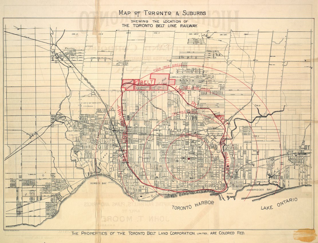
The railway consisted of two separate loops, both commencing from Union Station. The eastern loop circled around the north end of the city via the Don Valley, Mount Pleasant Cemetery and the Grand Trunk Railway tracks in the west, while the western loop passed through Swansea, Lambton and West Toronto Junction, returning to Union Station, via Parkdale.
A lot of money was raised, but most was spent on lavish promotion. The Grand Trunk Railway took over the project, finished the construction and opened the line in 1892. However, by that time a depression had caused the real estate market to fall and sales were low. The land boom did not materialize.
On November 17, 1894, after just 27 months, service ended on the Toronto Belt Line railway. With little development, the line was soon starved of paying passengers. By July 1894, there were only three trains a day on each of the loops, and by November, service was ended.
The land remained unsold until street railways were built into the area in 1910. Today, no tracks and buildings remain, but the Belt Line has become a very popular park [Kay Gardner -N.] winding through the city.”
- Combining text from: TPL, All Aboard Toronto! - Railways and the Growth of a City and City of Toronto Archives, This Month in History: 1892, closure of the Belt Line Railway
Click the image to view a full-size (5MB) version.
Map of Toronto & Suburbs Shewing the Location of the Toronto Belt Line Railway. Published by Alexander & Cable, Toronto.
Image courtesy TPL. I believe this map may in fact be dated 1910; I’ve potentially misleadingly labelled it 1892, to place it in context with the operation of the line.
The central point indicated is Queen’s Park.
Of note is the reversed text faintly visible as ink showing through from the other side. At the top: Highlands of Toronto. At the bottom: ‘For descriptive pamphlets, plans and prices apply to John T. Moore, Manager’
The Highlands of Toronto was a prospectus -- essentially, a real estate sales brochure -- published in 1891 by the aforementioned Toronto Belt Land Corporation, extolling the benefits of the Belt Line and the picturesque nature of the bucolic suburbs it made accessible. John T. Moore, president of the Institute of Chartered Accountants, was the managing director of the Corporation (Moore Park is named after him).
The following bird’s eye view map of the Toronto Belt Line Railway appears at the end of the prospectus.
Click the image to view a full-size version.
Other elements leading to the failure of the business were the fare (25 cents, quite high at the time) and the competing Toronto Street Railway, which carried considerable traffic as it was faster, providing more direct routes to downtown.
 |
| Bottom left: the Yonge St. Belt Line crossing |
- The Highlands of Toronto
 |
| A modern view for comparison (via Google maps) |
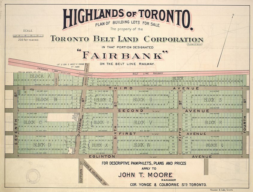
Going back to the first map, note the sections highlighted in red: Spring Valley (Moore Park), Forest Hill, Fairbank, Fairbank Junction. The developer would have been attempting to sell plots of land in those sections.
This map illustrates the lots available in Fairbank:
Click the image to view a full-size version.
Highlands of Toronto plan of building lots for sale the property of the Toronto Belt Land Corporation in that portion designated "Fairbank" on the Belt Line Railway. Published by Alexander & Cable, 1910.
Map courtesy Toronto Public Library: T[1910]/4Msm
Bonus Map showing the ‘Northern Suburbs of Toronto’ in 1890. The Belt Line is marked in red:
Click the image to view a full-size version.
Belt line map shewing northern suburbs of Toronto. Compiled by Unwin, Foster & Proudfoot, published by Alexander & Cable, 1890.
Map courtesy Toronto Public Library: T1890-2/4Mlrg c1
Portions of the belt line were re-used for freight operations: the Yonge Loop delivered Canada’s first subway cars to Davisville Station in 1954 and also supplied Dominion Coal on Merton Avenue up until 1969.
See Also
1892 Toronto Railway Company Map Shewing Toronto Street Railway Lines
1876 PA Gross Bird’s Eye View of Toronto
1886 Wesbroom: City of Toronto [Bird’s Eye View]
1893 Barclay, Clark & Co. Bird’s Eye View Chromolithograph
Further reading:
Toronto Beltline - article by Derek Boles, Toronto Railway Historical Association
1876 PA Gross Bird’s Eye View of Toronto
1886 Wesbroom: City of Toronto [Bird’s Eye View]
1893 Barclay, Clark & Co. Bird’s Eye View Chromolithograph
Further reading:
Toronto Beltline - article by Derek Boles, Toronto Railway Historical Association
Please ‘Like’ and Share these maps with other Toronto history enthusiasts! (+1s are also welcome!)


