‘The first public water supply in the Toronto area was a private company operating from 1843 to 1873, known as the Furniss Works (Toronto Gas, Light and Water Company). In 1873, the responsibility for supplying water was taken over by the City of Toronto administration. Extensive additions to the system followed immediately, including the construction of the Rosehill Reservoir, additions to the John Street Pumping Station and an improved distribution system.’
In March 1874, the provincial goverment passed An Act Respecting the City of Toronto Water Works, confirming the sale and transition of the Furniss Works to the City. Subsequently, city bylaws 885 and 886 established a tariff of water rates and the formal establishment of the Water Works Department of the City of Toronto.
Click the image to view a full-size version (5MB).
Plan of the City of Toronto, Shewing the General System of the New Water Works and Position of All the New Pipe Laid. Printed by Copp Clark & Co. Lithographers, 1878.
Image courtesy University of Toronto Map and Data Library: G3524 .T61 N44 1878.
Note the pipe to the Toronto Island infiltration basin.
An earlier version of the map from 1876 showing the intended plan of construction for comparison (click to view large version):
Image courtesy Toronto Public Library: MsX.1921.11.
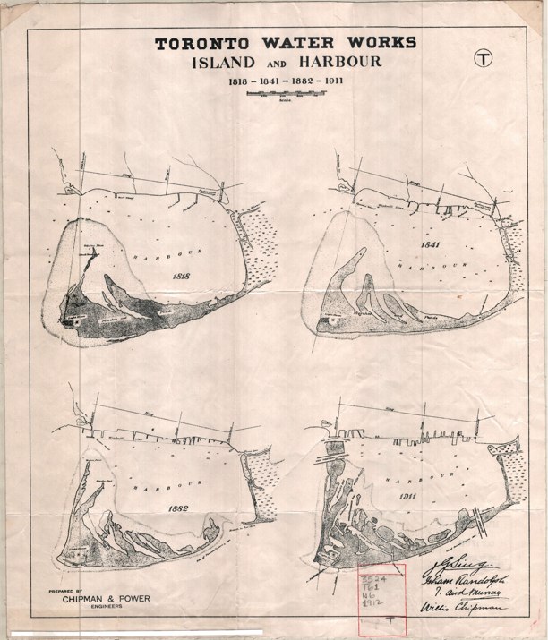
Bonus map: Toronto Water Works, Island and Harbour; 1818-1841-1882-1911, prepared by Chipman & Power for the Toronto Board of Commissioners on Water Works, 1912. The changing shape of Toronto Island is quite noticeable.
Click the image to view a full-size version (3MB).
Accompanying the above map was this Toronto Water Works Plan Showing Pollution of Lake Shore and Results of Analyses (2MB).
These two maps were part of a 1912 Report upon the existing water works system and upon an additional water supply (courtesy University of Toronto Map and Data Library).
See Also
- 1858 Unwin Plan of the City of Toronto - Sewers
- Mahesh Patel. The long haul: Integrating water, sewage, public health and city building, in HTO: Toronto’s Water from Lake Iroquois to Lost Rivers to Low-flow Toilets
Please ‘Like’ and Share these maps with other Toronto history enthusiasts! (+1s are also welcome)


